The Achen Valley extends to the Austrian-German border and connects the Lower Inn Valley in Tyrol with the Isar Valley in Bavaria. Lake Achensee is nestled in this beautiful valley.
With a length of around 9 kilometers, a width of up to one kilometer and a maximum depth of 133 meters, Lake Achensee is the largest natural lake in Tyrol.
But how did this impressive alpine lake form?
The glaciation of the Alps played a crucial role in the formation of Lake Achensee. During the last glacial period (Würm Glaciation: 115,000 to 11,700 years ago), a massive glacier carved out a deep basin in the Achen Valley, which today forms the lake’s basin.
However, glaciers not only shaped the lake basin itself but also created a natural dam south of the present-day lake. Enormous ice masses from the Ziller Valley advanced into the Inn Valley, depositing a massive barrier of glacial debris at the entrance to the Achen Valley—now known as the Achensee Dam. Rising up to 150 meters high, this natural barrier retains Lake Achensee to the south and separates it from the significantly lower Inn Valley.
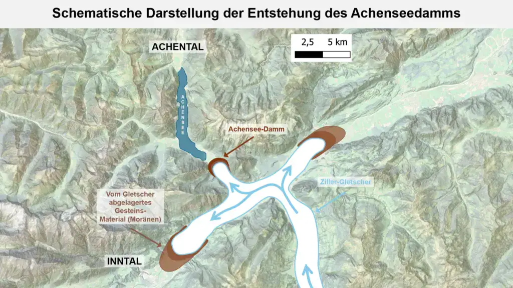
Here you can see how the Achensee dam is believed to have formed: During the last Ice Age, the Ziller Glacier flowed northward from the Ziller Valley and deposited large amounts of rock material (moraines). The Achensee dam is a natural barrier that impounds Lake Achensee to the south and separates the Achen Valley from the Inn Valley, which is approximately 400 meters lower. (Image source: Own illustration)
Lake Achensee then and now
If you look across the Achen Valley, it is hard to imagine that during the last glacial maximum the ice thickness in the valley was around 800 meters. Only the highest peaks, such as the Seebergspitze in the west and the Hochiss and Rofanspitze in the east, still protruded from the mighty ice masses. Mountains such as the Ebner Joch and the Bärenkopf in front of you, on the other hand, were completely covered by ice.
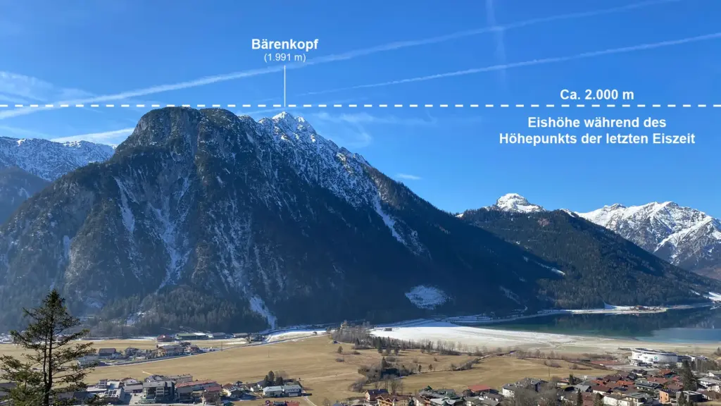
The Achen Valley was buried under glacial ice up until the Bärenkopf during the last ice age around 20,000 years ago.
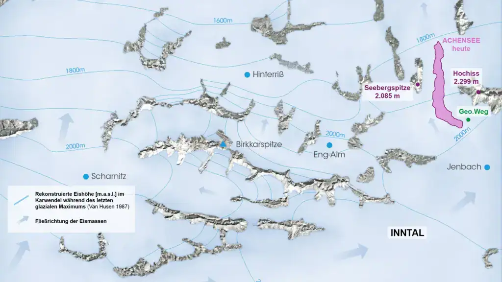
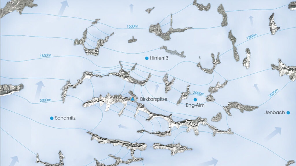
The map shows how great glacier masses covered large parts of the Alps during the maximum of the last ice age. In the area of today’s Lake Achensee, the ice masses mainly moved northwards. The reconstructed ice height in the Achen Valley was around 1800 meters. Only the highest peaks protruded from the ice – these are known as nunataks. (Image source: Van Husen, 1987)
The Achen Valley, carved out by glaciers, was originally much deeper than it is today. Over time, the valley basin was filled with sediment and rock material forming the present-day valley floor.
The outflow direction in the Achen Valley also changed after the formation of the Achensee dam. Originally, the valley drained southward into the Inn Valley. Today, however, due to the dam, the lake drains northward toward Germany.
Not only the outflow direction, but also the lake level of Lake Achensee has undergone significant fluctuations over time. Just a couple thousand years ago, the lake level was about 10 meters higher, and the shoreline extended at least 650 meters further southeast. Evidence for this can be found at Eben where lake sediments were discovered. These findings show that Lake Achensee once extended far beyond its current shoreline. Where water once was, there are now houses.
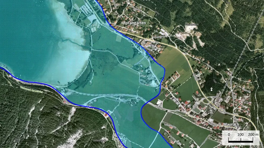
Here you can see roughly where the lake shore (blue line) was when the lake level was 10 meters higher. Some houses now stand where the lake once extended. (Image source: Vinke 2016)